The Angeles National Forest has a snow season that can start as early as November and last until as late as May, depending on conditions. The "front range", i.e. the 5000' peaks like Mt. Wilson that are closer to Los Angeles experience snow less often than the "back range" which are the 7000'-10000' peaks like Mt. Waterman and Mt. Baldy, which often have snow pack for months at a time.
L.A. County rises from sea level to over 10,000', meaning you can surf and ski in the same day. Winter activites you can enjoy in the San Gabriels include cross country skiing, snowshoeing, technical mountaineering, ice climbing, splitboarding, backcountry skiing, resort skiing, or just throwing chains on your trusty 1990s Honda civic and making a snowman with your kids. Accessing these areas in snow season safely requires knowing about a few things: chains, weather, timing, and road closures
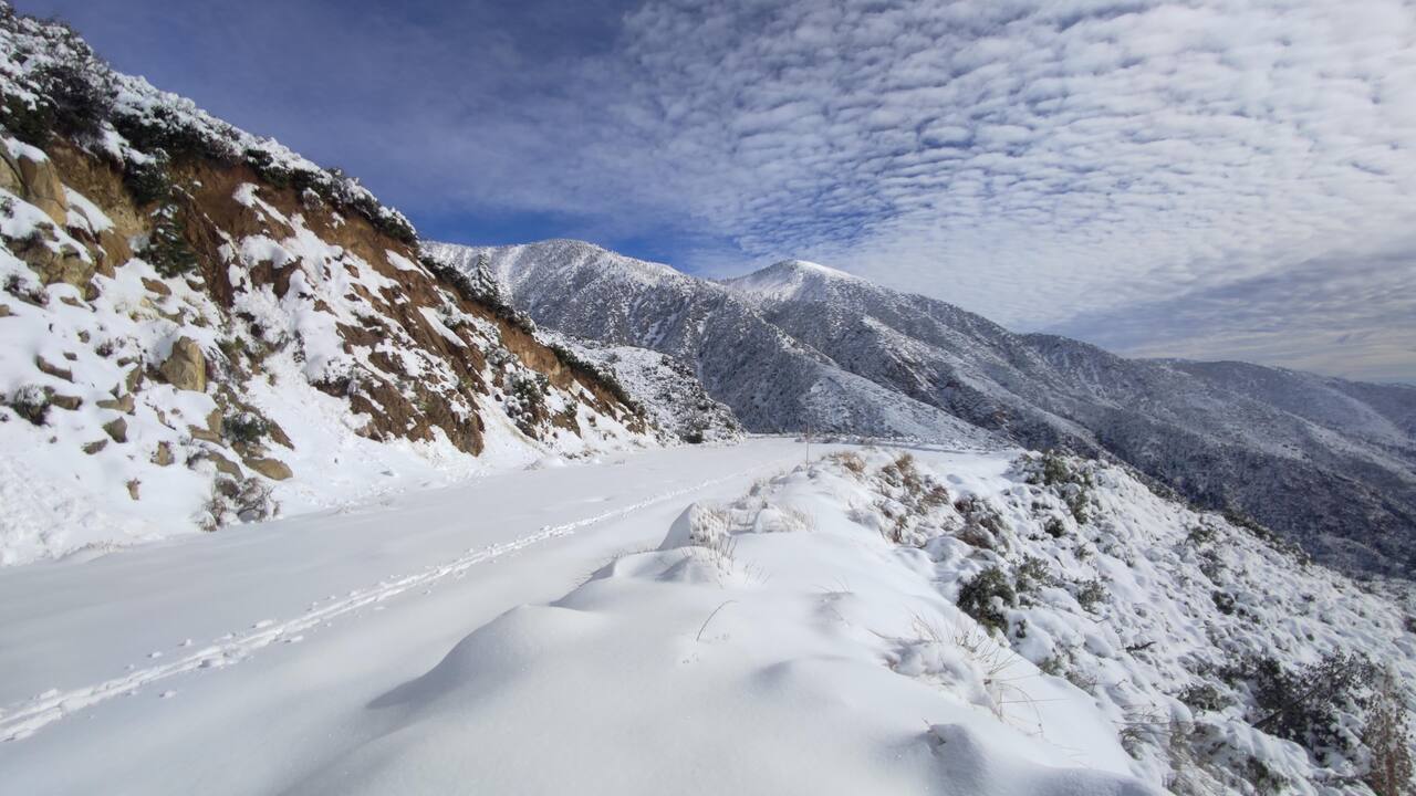
The author cross country skiing up SR-39 just past the gate closure
Chains
The most important thing you will need is a pair of chains that fit your cars tires. Yes, you absolutely need them. Many people are surprised to see how much snow is in the back range, as it can be difficult to see the back range from many neighborhoods in LA. You might look up at Mt. Wilson and not see any snow, but after 45 minutes going up SR-2 you will be in a couple feet of snow and wishing you had your chains. Unlike the Sierra Nevada where CalTrans has mandatory chain inspectors ensuring every vehicle entering the mountains has chains on board, CalTrans in SoCal does not perform these checks, so it is up to you to remember to bring your chains.
Weather
A good source for mountain snow forecasts is weather.gov. Use the map on their forecast page to click a specific area to get a spot forecast. You can then generate a hourly chart showing rain and snowfall levels for that specific area. Here are 3 spot forecast links to compare:
If you check these before a storm, you will usually see that Mt. Baldy will receive much more snow than Mt. Wilson, with Mt. Waterman somewhere in the middle.
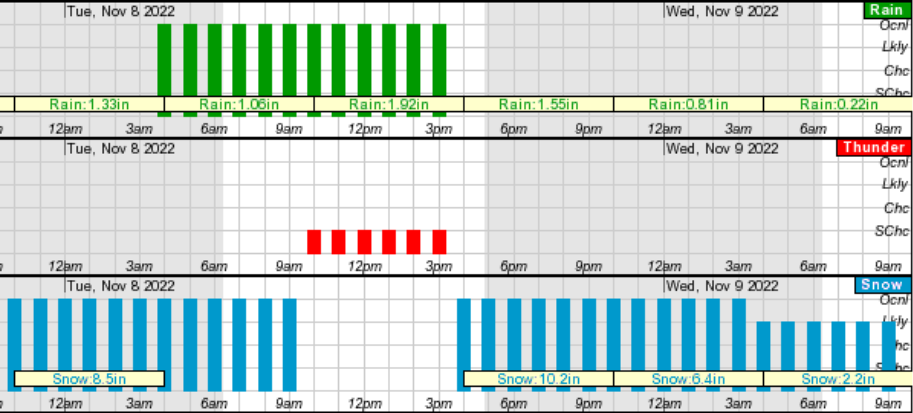
Mt. Baldy Forecast For November 8th, 2022
You can also consult the Snow Cal Snow instagram account, which posts detailed analyses of snow and avalanche conditions in the San Gabriels for most storms: https://www.instagram.com/socalsnow/
Timing
If your goal is to access fresh snow and beat the crowds, the best time to go is the morning after a snow storm on a weekday. For example if a snow storm hits on a Wednesday, then Thursday morning will offer the best snow conditions quickest access. If you wait until Saturday to go, the snow condition will have deteriorated due to multiple freeze-thaw cycles and you run the risk of getting stuck in a traffic jam. Popular areas should be avoided if possible on weekends after big storms, as many weekend visitors do not carry snow chains and a single car scared to descend an icy road can hold up hundreds of cars behind them for hours. Mt. Baldy Village and Wrightwood generally experience huge traffic jams in the late afternoon on weekends as hundreds of cars all try to leave at the same time.
Road Closures
The roads used to access the Angeles National Forest for most people will be State Route 2 (SR-2, aka ACH or Angeles Crest Highway) or State Route 39 (SR-39). Both of these being State Routes are managed by CalTrans and have snowplows with GPS trackers on them.
You can view the snow plow locations as well as the closures on the CalTrans QuickMap website.
Under Options click Road Conditions and then check all the boxes in that section. Zoom in to the Angeles forest area and carefully check the information on the area you are planning on visiting. If QuickMap is up to date then you will see exactly where they are plowing and where the road is closed. Sometimes QuickMap is not up to date and you will drive up only to find a closed gate miles before any closures are shown on QuickMap. It can also be helpful to check the CalTrans SoCal Twitter for any additional updates before you leave on your trip: https://twitter.com/CaltransDist7, they also generally respond to questions in a timely fashion. The official ANF twitter is also a great source of real time info https://twitter.com/Angeles_NF
For the SR-39, the best place for information is the Crystal Lake Cafe Facebook Page. Crystal Lake Cafe is open year round and posts almost daily photos in winter regarding road conditions and weather. Make sure to stop in and say hi to the owner Adam and enjoy a high elevation hot chocolate or cheeseburger.
Both SR-2 and SR-39 use a gate system, where the snow plow operators generally close a gate at a certain elevation level depending on the snow fall amount and then try to keep the road up to that gate plowed and accessible. For example on SR-2 there are gates around the 5000' point, the 6000', the 7000' etc. During a very heavy snow storm they may choose to close the gate at a lower elevation. On SR-2 during the snow season you can never drive all the way from La Canada to Wrightwood, there will always be a gate closure, generally from Islip Saddle to Big Pines. On SR-39 the gate between Islip Saddle and Crystal Lake is always closed (for 30+ years), you can never drive that section.
If you are planning on visiting e.g. Mt. Waterman (~8000 ft) but the snow plow operators have closed SR-2 around 6000ft, then you may be out of luck and need to change plans. The gates generally have parking areas that will also be plowed and will be near pit toilets, so if your trip is cut short by a surprise gate closure, you may have to park there and enjoy the area around the closed gate or continue past the gate closure on foot (or cross country ski).
You can view all the gates and points of interest on this handy map: https://caltopo.com/m/8A0P
Other roads such as Angeles Forest Highway (not to be confused with ACH), Mt. Baldy Road and Big Tujunga Canyon are not managed by CalTrans and therefore you won't see closures on QuickMap. You will have to find local sources of information on closures for these routes.
Stay safe and enjoy the snow!